Holidays
Where did I go over the holidays. Firstly, camping in Croajingalong National Park, (Google Earth 37°46'42.81"S149°19'27.41"E). Point Hicks was Captain Cook's first sighting of the east coast of Australia in 1770. Camping with 3 12 year old boys is not for the faint hearted!
Next, bushwalking at Three Mile Dam. It was built by the Chinese in 1882 to provide water for gold sluicing. (35°53'17.72"S148°26'57.29"E)
Next, bushwalking at Three Mile Dam. It was built by the Chinese in 1882 to provide water for gold sluicing. (35°53'17.72"S148°26'57.29"E)
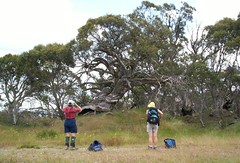
Snowgums near 3 mile dam
Then bushwalking round the Bogong High Plains (36°55'42.80"S147°17'41.01"E ) and a cycling tour of the mountain huts.
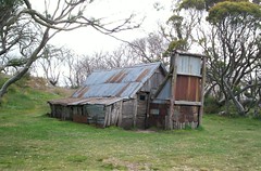
Built in 1889 from snow gum slabs and woollybutt shingles, Wallace's hut is thought to be the oldest in the high plains.
And over to Mount Bogong (36°45'17.64"S147°19'55.30"E) to man the checkpoint for the Rooftop Run. The runners run through some of the remotest alpine country in 8 hours! Mt Bogong is Victoria's highest mountain.
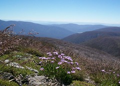
Wildflowers near Mt. Nelse
And Lakes National Park (37°59'43.47"S147°39'9.19"E ) for a kayak trip. Watching black swans taking off is awesome.The complete photo set at http://www.flickr.com/photos/49912796@N00
/sets/72057594050512667/
posted by Unknown at 2:43 PM
2 comments
![]()
![]()
